 |
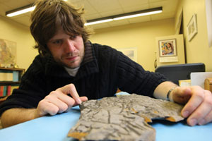
| For his research, Neil Davies took a look at the fossil record at dozens of sites throughout the world. (Nick Pearce Photo) |
This is a time of continents colliding, North America and Greenland hitting Europe, smashing together and making mountains. The planet’s land mass is mostly dusty and barren. Rivers were more like great expanses of water sliding into the ocean.
“You’d hardly know the place,” says Martin Gibling, professor with HÂţ»â€™s Department of Earth Sciences. “There was bare rock and sand, with crusts of bacteria and algae over the rock surfaces. And ancient rivers were very different, like big sheets of water carrying sand and gravel. They weren’t like channels whatsoever.”
Dr. Gibling and postdoctoral researcher Neil S. Davies wanted to find out more about those big rivers. What happened during the evolution of the Earth to throw them for a loop?
“If you think of a river, it’s wavy, it’s meandering,” explains Dr. Gibling. “A river has curves, eroding into its bank on one side, and depositing sediments on the other.”
For the answers to one of the most significant environmental changes in the Earth’s history, they turned to the fossil record using a literature compilation and fieldwork. Their research took them to 35 sites around the globe, including Port-au-port, Newfoundland, the Gaspé Peninsula of Quebec, the Channel Islands off the coast of France and Death Valley in California.
The difference, they discovered, came with the earliest plants. By stretching their roots down, they stabilized river banks. Instead of wide and sheet-like, rivers evolved to become more confined and narrower. Their research, highlighting the co-evolution of land plants and river landscapes, has just been published in the journals Geology and Earth-Science Reviews.
“Once the plants started to get a toehold, they sent spores into more inland areas,” says Dr. Davies, who hails from Birmingham, England. “The entire process took about 50 million years, with vegetation spreading until it dominated every landscape except total desert. The Earth could never be the same again.”
SEE: “” in Earth-Science Reviews, February 2010
“” in Geology, January 2010
